

Trippet Stone Circle
- HelenArt
- Jun 2
- 2 min read
Sketching with the skylarks at Trippet Stone circle, near Blisland, Bodmin moors.
Starting further south, just north of the A30 the vegetation change in the shallow valley suggested a boggy area. We did not stray down into the rough sedges but some moorland cows confirmed this, ankle deep in a muddy pool.
By the time this water course reaches the area of the Trippet stones, it has coalesced into a stream and dropped into a small steep valley that separating the common from the rising slopes of Hawks tor. It carries on to join the De Lank river which descends across the high open moors from Rough tor marsh to join the Camel. The Trippet stones, on their small patch of flat moorland with overhead lines cutting through close by and close to tarmac.

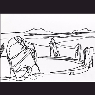


Trippet stone circle is located on flat and rather featureless piece of moorland, known as Manor common but connected by sight and water to the higher moors including the enigmatic Rough tor, and closer by – Hawks tor and Carbilly.
It is true circle of 8 remaining standing and leaning stones, and four more recumbent- as with many surviving circles in is incomplete. There were once around 26 stones (based on the assumption of equal spacing). Over the millennia the stones have been broken up or removed for re-use elsewhere – we spotted a quite impressive stone wall on the opposite side of the cross-roads with some large stones at the base. I suspect a few may have been from the circle.
On the skyline, just below Carbilly tor, the Carbilly Cheesering sits in silhouette and on the slopes of Hawks tor the Stripple stones and henge are visible.


Comments